


Elections to the Bishkek City Kenesh. How the parties divided the city and what districts affected the outcome
Elections to the Bishkek City Kenesh. How the parties divided the city and what districts affected the outcome.
Over the past year, Kyrgyzstan has seen four election campaigns. New data have become available that can be used, analyzed, and interpreted by all of us. This is at the heart of the Open Data concept, which is gaining momentum in our country as well.
Using the data published by the CEC, we tried to analyze the Bishkek City Council elections of July 11, 2021. The turnout was predictably low: according to the hand count, just over 104,000 voters cast their ballots or 24.41 percent of those on the voter list.
The CEC's open data helped us to find out in which part of the city the highest voter numbers influenced the voting results, and how the leading parties were positioned on the map of the capital based on the election results.
Usually, we divide Bishkek into four administrative districts: Leninsky, Oktyabrsky, Pervomaysky, and Sverdlovsky. Of considerable interest is also how the voter landscape looks like according to the geographical location of polling stations.
Our objectives for the analysis were as follows:
- Show on the map of Bishkek how the leading parties were positioned according to the voting results.
- Show on the map the density of voters according to the list of registered voters;
- Show quantitative and percentage voter turnout on the map relative to the list of voters for the election of July 11, 2021;
For our analysis, we divided the city into nine notional zones, depending on the geographical location of polling stations, identifying the following categories:
- Central part of the city;
- Small house suburbs, departing from the center;
- Residential areas located in the northwest and northeast, southwest and southeast;
- South and east microdistricts.
For a detailed description of the boundaries of the notional zones, see Appendix No. 1, or on the maps themselves.
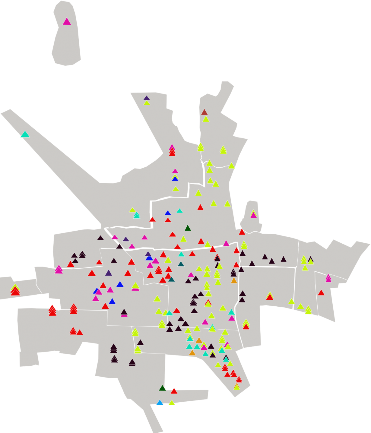
Thus, overlaying the data provided by the CEC for each polling station on the map of Bishkek, we could see how the leading parties were located by polling stations (Map 1).
Each triangle on the map is a polling station. The overlapping triangles are polling stations in the same building.
Some sort of pattern emerged that the city split in its party selection preferences.
Thus, "Ata-Jurt Kyrgyzstan" and "Ishenim" parties are leading on the outskirts of the city: in residential areas located in the southwest.
In the northeast, near Dordoi and Enesai, the "Emgek" party leads.
The "Yntymak" party received its support more from the west of the center square.
In the same territory, the "Social Democrats", who were in the minority, received the support.
We see some diversity in the voter preferences only in the city center and in the southern microdistricts, where there are relatively more parties in the lead at the polling stations. Thus, the "Reforma" party took the lead in some polling stations only in those zones, which diversified the leading positions.
Looking at the map, there is a certain pattern of party leadership in certain areas of the city. For example, the same party leads in those locations where two or three polling stations are located in the same building, or the PECs are located close to each other.
For example, looking at the polling stations located in the southwest, the same "Ata-Jurt Kyrgyzstan" party is leading in 10 PECs that are close to each other or in the same building. A similar picture can be seen almost all over the city.
Let us now see how the density of voters and their turnout are placed in the notional zones that we have defined.
Map 2 shows the density of voters registered in 228 PECs in Bishkek.
On Map 2, we see that in the central square and in the southern microdistricts, the PECs are placed densely, at a fairly close distance from each other.
In residential areas, on the contrary, there are relatively few polling stations on a large area, situated at long distances from each other, and several polling stations can be located in one building at once.
In the central part of the city and neighborhoods population density is higher due to the storey building, the same can't be said for residential areas, where there are mostly one-story houses.
If the density of registered voters in the list is presented on the map according to the notional zones that we have set, we get the following picture:
In terms of the total number of voters, the center is in the lead, with a total of 94,603 voters registered at the polling stations in 55 PECs within the range we have set, while in the southern microdistricts there are 80,928 voters in 43 PECs.
The smallest number is represented in the north-eastern residential areas: "Kelechek", "Dordoi", "Enesay", "Bakai-Ata" - 10,748 voters in 9 PECs.
An interesting situation is also unfolding in terms of voter turnout.
Map 4 shows the number of voters who came to vote by PECs separately.
In areas with a high density of voters we see paler triangles, which means there is a low turnout.
The percentage turnout relative to the voter list in the center and southern microdistricts is also very low (Map 5).
Only two polling stations, again close to one another, had the highest percentages of voter turnout: PEC No. 1150 - 45%, PEC No. 1157 - 46.2%.
Now, see what the picture of percentage turnout looks like, summed up by our notional zones (Map 6).
It turns out that the lowest turnout is observed in the southern microdistricts (No. 3, 4, 5, 6, 7, 8, 9, 10, 11, 12, "Asanbay", the area of KGUSTA, KGMA, "Djal", the Ataturk park area) and the highest - in the south-western residential areas ("Ala-Too", "Ak Ordo", "Ak Orgo", "Archa-Beshik", "Yntymak", "Orto-Say").
Regarding the purpose of our analysis (in which part of the city did voters have more impact on the election results of July 11, 2021), we see the following:
Despite the fact that the central square and the southern microdistricts have a low turnout at the polls, due to the density of voters, these are the areas that mostly influenced the voting results.
But the number of voters in the northeastern residential areas affected it less than in other notional zones in the total pool of valid votes.
Thus, using open data, we obtained a map of the leading parties and districts that influenced the results of the Bishkek City Council elections. Mapping analysis can baffle anyone and make us interpret the voters' choices or the parties' strategy differently.
Appendix No. 1
1. We included the range confined in the central part to the streets: in the south - Akhunbaeva, in the east - 7 April, in the north - Jibek-Jolu and in the west the line consisting of the streets: Fuchika, Moskovskaya, Kulieva, L. Tolstoy, Ch. Aitmatov.
By setting this range, our logic was based on the fact that this area has the largest number of PECs at a relatively short distance from each other. In addition, this area is a central part of the city, compared to other areas, with a high density of voters, as well as a concentration of administrative buildings and business centers.
As for the small house suburbs, we divided them as follows:
2. The small house suburbs to the north of the center are confined to the following streets: in the south - Jibek-Jolu, in the west - Fuchika up to the "Kolmo" residential area along Saadaeva Street, then along Kollektornaya Street up to Nizhnyaya Ala-Archa. In the north: along Aula Street, Dordoi Ibraimova Street, Gidrostroitelnaya Street, in the east - Alma-Atinskaya Street.
3. Small house suburbs to the west of the center, including Rabochiy Gorodok, Kyzyl-Asker, and Gaz-gorodok.
Residential areas and new buildings, stretching from the center in a circle in all directions with relatively new settlements, represent an interesting picture on the map of Bishkek.
We have also divided the category of residential areas into the following several zones:
4. In the northeast: "Kelechek", "Dordoi", "Enesay", "Bakay-Ata".
5. In the northwest: Voennyi gorodok, "Kasym", "Aska-Tash", "Prigorodnoe", "Kolmo", "Ak-Bosogo", "Maievka", "Krasnyi Stroitel", "Krasnyi Stroitel-2", "Ak-Jol" residential areas. We also included the "Dostuk" microdistrict, the new housing developments "Kalys-Ordo" and "Muras-Ordo".
6. In the southwest: "Ak-Orgo", "Archa-Beshik", "Selektsionnoe", "Yntymak", "Chon-Aryk", "Orto-Say".
7. In the southeast: "Kok-Zhar", "Kara-Zhygach", "Altyn-Ordo", "Uchkun", "Rukhiy Muras".
8. In terms of geographical location, the southern microdistricts above Akhunbaeva Street are also separated: Nos. 3, 4, 5, 6, 7, 8, 9, 10, 11, 12, "Asanbay". This also includes the "Djal" microdistrict and the Ataturk Park area.
9. Eastern microdistricts: "Tunguch", "Alamedin-1", "Gorodok Energetikov" and "Gorodok Stroiteley".